By Jason Nicholls, AccuWeather senior meteorologist
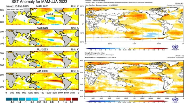
The rare triple La Nina is waning with a weak central Pacific La Nina signature to the sea-surface temperatures expected in March. The atmosphere is still lagging behind the changing sea-surface temperatures in the equatorial Pacific, so we are expecting a La Nina-like atmospheric pattern early in the spring followed by neutral ENSO conditions mid- to late spring. El Nino conditions can develop late in the year, but neutral conditions should prevail much of the spring. Here is a look at forecast sea-surface temperatures.
Courtesy APEC Climate Center and WMO
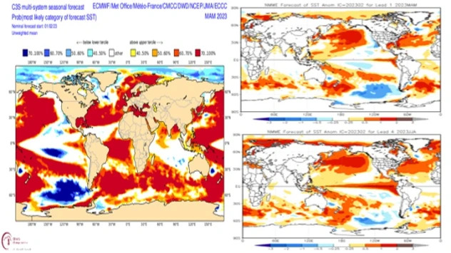
IMME and NMME
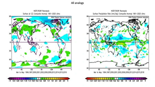
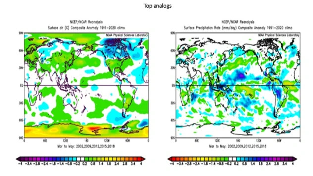
Before looking at the forecast, here is what our analog years show.
Now to look at specific regions.
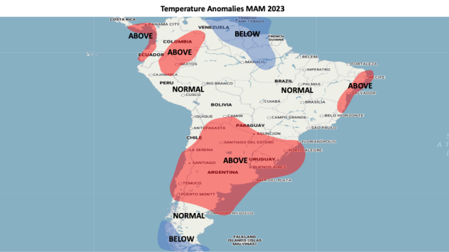
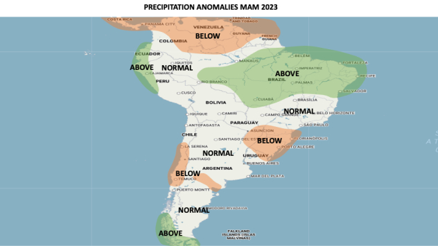
Brazil:
Heat will remain a concern across the crop areas of Rio Grande Do Sul in March and perhaps April where heat and dryness have been a problem during the summer. Drought conditions will continue in the area as well early in the season, but rain prospects can improve later in the season as La Nina atmospheric conditions wane. Dryness can also be a concern across portions of Santa Catarina early in the season with the risk for some heat, then precipitation can average near to below historical averages late in the season. The remainder of Brazil will have precipitation at least near historical averages, but the Amazon basin and northeast Brazil can be wetter than historical averages. An early frost or freeze appears unlikely in southern Brazil.
Temperatures across central and northern Brazil will be near to slightly above historical averages, but lower in far north-central Brazil. Far northwest and north-central Brazil can start autumn on a dry note but is expected to turn wetter late in the season as sea-surface temperatures off Ecuador should gradually rise as La Nina fades.
Argentina, Uruguay and Paraguay:
Northern Argentina and Uruguay into Paraguay will continue to have heat and dryness concerns early into midautumn, but it looks like rain prospects can improve late in the season as the La Nina-like atmosphere finally spins down in response to the changing SST anomalies in the equatorial Pacific. A quicker spin down of La Nina could mean better rain prospects returning in April.
Central Argentina is expected to be drier than historical averages in March with some bouts of heat, then more seasonal across these areas in April and May. Dryness problems can linger into April with rainfall expected to be near historical averages in May.
Southern Argentina should have temperatures near to slightly below historical averages with precipitation mostly near historical averages.
There is a low risk for an early frost and freeze in these areas with a better chance for a late freeze, but there is a risk for early snowfall in far southern Brazil.
Chile:
Much of central and northern Chile, including the wildfire areas, will be warmer and drier than historical averages with heat waves likely through at least April. This will result in worsening drought and a high wildfire threat continuing in these areas through much of the season. Warming of sea-surface temperatures off northern Chile may result in the chance for rainfall late in the season.
Temperatures can be closer to long-term averages in southern Chile with some spells of cold possible mid- to late season. Precipitation will be near to above historical averages in the area with early snow possible, especially over the southern Andes.
Ecuador, Colombia, Peru and Bolivia:
Rather dry across these areas to start autumn with rainfall expected to be near to above long-term averages during mid- to late autumn. Quicker warming of sea-surface temperatures off the coasts of Ecuador and Peru may help ensure a faster start to the wet season. However, northern and eastern Colombia is expected to average drier than historical averages. Temperatures should average near to above historical averages for the season, but the warmest weather with respect to averages is expected early in the season.
Venezuela to French Guiana:
Rather cool early in the season across this area, then temperatures should rise above historical averages in April and May. There is a chance this area could turn out warmer than forecast, especially with a quicker return of warmth.
ENSO trending neutral to perhaps weakly positive (El Nino) should result in rainfall below long-term averages for the season. However, French Guiana and Suriname could end the period on a wetter note.


